If a game, game-like learning environment or any other software using game technologies is based on real events, the relationship between realism and playability has to be taken into consideration during the development process. Imitating the real world precisely with all its limitations set by physics, biology or the passage of time doesn’t necessarily serve the original purpose or goal of the game or software. It doesn’t matter if the goal is to entertain or to educate, both can suffer from total realistic accuracy.
Making a game replicate its real-life counterpart as precisely as possible is sensible and sometimes absolutely necessary when a game is focused on a very limited subject, such as controlling a specific vehicle. In the case of vehicle simulators, the physical controllers are also often made to look and feel like the real thing. On the other hand, when the subject of the game is broader, decisions have to be made on which things to replicate and which things to change to enable e.g. playability, entertainment or better understanding of the bigger picture. The intended platform of the game also plays into these decisions. A keyboard-mouse combination, regular commercial game controller or a smartphone screen are all very generic controllers and as such can’t exactly replicate the feel and functions of any specific tools or items. If the chosen platform is mobile, physical size and performance of the devices as well as the inaccuracy of gesture controls set extra limitations.
This balancing between realism, hardware limitations and the goal of the game has been and will continue to be an integral part of the design process of Struve Geodetic Arc mobile game. The game is being produced as a part of The Northern parts of the World Heritage Struve Geodetic Arc project (struvenorth.net), partially financed by EU’s Interreg Nord programme (ERDF).
The background story: What is the Struve Geodetic Arc?
Friedrich Georg Wilhelm von Struve (1793-1864) was an astronomer who also had an interest in geodetic surveying. As a part of his research he organized a triangulation survey with a triangle chain reaching from Black Sea to Hammerfest. The goal of this survey was to gain a better understanding of the shape of the Earth near its poles. The whole chain includes 258 main triangles and 265 main station points that stretch over 10 different countries. A total of 34 of the main station points are part of UNESCO World Heritage. (maanmittauslaitos.fi)
Struve Geodetic Arc was accepted into the UNESCO World Heritage list in 2005, but it isn’t particularly well known in the Nordics. The Northern parts of the World Heritage Struve Geodetic Arc project aims to improve the accessibility and knowledge of the Struve Geodetic Arc. The purpose of the mobile game is to attract new audience for the World Heritage site by means of entertainment.
The events and environment of the game are based on real events in what is currently Finland, Sweden and Norway, then Sweden-Norway and the Russian Empire, during the 19th century. However, the intent is not to make a “real” educational game or replicate historical events and circumstances as precisely as possible, even though it would be possible in theory. Struve Geodetic Arc mobile game has been intentionally designed to handle its real-life backstory with a lighthearted and entertaining touch. The reasons behind these decisions can roughly be divided into three parts: reaching casual gamers, creating a better flow for the story and limitations of the mobile platform. These reasons and historical accuracy aren’t necessarily mutually exclusive, but in this project the choice was made to favor entertainment and casual approach.
Handling time and order of events
When a several hundred pages long novel is adapted into a movie, the events of the story are shortened and perhaps rearranged to some degree, in order to make all the important things fit in a more compact format and to keep the viewer engaged for the entire duration of the movie. Time and order of events have been approached somewhat similarly in the development process of the Struve Geodetic Arc mobile game for the exact same reasons: limiting the total length of the game and making it easy for the players to follow the events and keep them interested in the game from start to finish.
In reality, measurements across the entire triangle chain spanned several decades. The focus of the game is mainly on the section going over Lapland where measurements also took years. Exactly replicating all events from a time period this long would inevitably make the game longer despite the way time is handled inside the game. A typical mobile game session isn’t very long: GameAnalytics, a company selling tools for analyzing game usage, states in their 2019 report that the average session length for a mobile adventure game was less than 15 minutes (GameAnalytics Mobile Gaming Benchmarks Report: H1 2019, p.13). If the total length of a game is measured in several dozen hours like in some current AAA-titles for PC or console, it would take a much larger amount of these average length sessions to finish the game compared to a situation where the total length is just a few hours. In the Struve Geodetic Arc mobile game one of the goals is to get the players to finish the game and go all the way to the northern endpoint of the triangle chain in Hammerfest. So, if the game in total is very long and following that the required amount of game sessions needed to finish the game is large, it is possible the players feel that the game is too long and won’t ever finish it. Keeping the players engaged until the end of the game is a good enough reason to give up accuracy.
It was never intended that the actual historical timeline would be completely removed from the game, however. At the current development phase (spring 2021) the game is being designed to have calendar years pass according to the game’s internal time and to give the player a goal to reach the endpoint the same year the actual measuring crew got there. Some known places of stay might also be matched with the correct years.
Much like handling time inside the game flexibly, it was decided that the order of events would be presented in a more linear fashion compared to reality. In the game the player’s party follows a route along the triangle chain in one direction, whereas in reality the measuring crew did not move linearly from point A to point B. During the measurements the crew stayed longer in some places than others and measurements in a certain area could be done as separate trips from one place of stay. In the early stages of design, it would have been possible to choose game mechanics that supported moving in a way more closely resembling the actual measurements, but the development team decided to make movement on the map more linear. The team felt it would be more motivating for the player to follow a clear route from one place to another compared to e.g. separate trips from one place and returning there every time. One factor in this decision was that in the earliest design stages the team didn’t have the information on the more exact routes, it became available at a later phase. Lacking this information, it was easier to design the game to have a linear route.
Handling time and events in a flexible manner sacrifices much of the historical accuracy. The reasoning behind this sacrifice is making the game more approachable. No background information or prior interest towards the subject of the game is required from the player. The game also doesn’t aim at educating players by force. The thought is first and foremost to offer a good experience. Then on the side tell the player about a subject that was possibly previously unknown to them and get them interested enough to find out more through other means.

Effects of mobile platform
Regardless of genre and content of the game, limitations set by the platform must be taken into consideration when developing a game for mobile devices. Even though the physical size and resolution of screens on mobile devices have been growing, the screens are still many times smaller compared to a typical laptop or desktop screen. This sets limitations to the number of menus or other elements that can be fit on the screen at one time while still maintaining legibility. In addition to this, mobile devices are typically controlled with finger input, which is considerably less accurate way of navigation compared to a game controller or a mouse. This in turn limits the smallest possible size e.g. buttons can be.
When better accuracy is required, mobile devices can be controlled with a stylus. A small number of stylus-controlled games have also been made. Controllers made specifically for mobile gaming are also being made and sold, these closely resemble console controllers. Both styluses and controllers are mostly sold separately, so when the aim is to reach as large audience as possible and make using the game easy, it is not reasonable to require the user to have any kind of special controller devices.
In terms of game design, screen size affects (among other things) the amount of information the player can be shown at one time. This amount can be regulated for example by showing only the information that is required in that precise menu or at that precise moment of the game. Another option is dividing the information into smaller sections and having separate menus or menu levels for each section. Neither of these options are without problems. If the total amount of the information the player needs is large and most of it is contextual and not shown to player at all times, the limits of short-term memory might prevent the player from keeping all required things in mind. Then again, multi-leveled menus can be hard to navigate. This means the only solution isn’t just dividing and categorizing information or changing the way it is presented. The game itself must be designed to be simple enough so that the amount of required information isn’t too great.
Poor accuracy of finger input means that the basic functions of the game can’t require precise or complex actions from the player. The controls of the game must be simplified to a few most important buttons and simple gestures so that the learning curve isn’t too steep and continued use is effortless.
The need for simplification means more adaptations and loss of historical accuracy. Actions that in reality are complex or demanding have to be made easier and more straightforward. In the case of Struve Geodetic Arc mobile game one example of this is the triangle measurement itself. The aim is to give the player factual information on the measuring process, but using the measurement devices required skill and precision and the actions won’t be precisely replicated in-game. The realistic measurement actions will be replaced with simplified versions or with an entirely another set of related activities. When the basics of the game are easy to learn and playing doesn’t require complex actions, more casual players or people who haven’t really played at all, can easily start playing Struve Geodetic Arc game.
What historical things are included in the game?
Despite putting game mechanics and the requirements set by the chosen platform first in the development process of Struve Geodetic Arc mobile game, the intention is not to make a generic adventure game and just have it wear a cosmetic skin with some historical influences. The project team has gathered information on e.g. the progression of the actual measurements, known places of stay and the day-to-day -life of people in the 19th century. The game development team has then incorporated this information into their designs. The game will have player to encounter problems similar to those the real measuring crew encountered. The remoteness and challenging weather conditions of Lapland affected e.g. the ways measuring equipment could be transported and when measurements could be performed in the first place. One example of these conditions is that during the 19th century the actual road network in Finnish Lapland, excluding winter roads, reached Kittilä, Kolari and Sodankylä, so when the player moves further north they can’t choose to use a road and have to advance by other means.
One goal of the game is also to have the player understand, how significant the measurements were to the society at the time. Using the information gathered from the measurements, new more correct maps could be drawn and the significance of good maps to trade and warfare for example was and still is great.
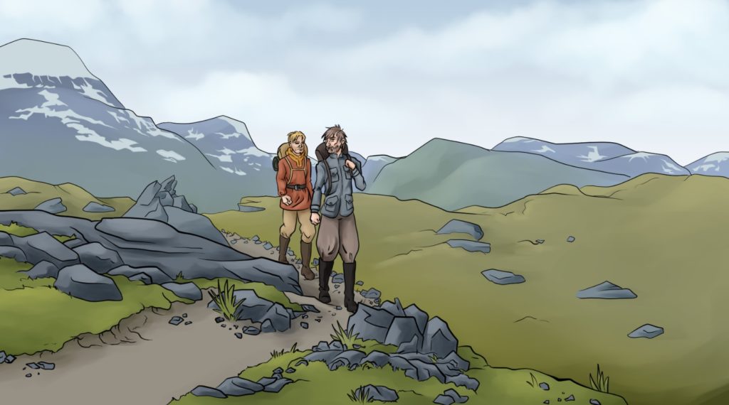
Visual elements are one of the ways used to convey information and feeling of the time period to the player. Even though the art style of the game is somewhat comic-like, the appearance of e.g. clothes, tools, buildings and measuring equipment is modelled after their real-life counterparts. The intent is to show events and life from nearly 200 years ago as lively and interesting despite deciding to give up true historical accuracy in many ways.
More on The Northern parts of the World Heritage Struve Geodetic Arc project: struvenorth.net
More on the Struve Geodetic Arc in general: https://www.maanmittauslaitos.fi/en/struvegeodeticarc
Game Analytics report of 2019: https://progamedev.net/wp-content/uploads/2019/07/Benchmarks2019.pdf